

Running in a new country can be tricky, but finding a high-quality, traffic-free, continuous path in Southeast Asia is a rare win. As a coach and competitive endurance hybrid athlete with multiple marathons and Full-Ironmans on my career, I always look for routes that deliver on two fronts: physiological utility (uninterrupted pacing zones) and visual stimulation.
During my stay at Le Méridien Kota Kinabalu, I mapped out a spectacular coastal route that delivers exactly that. It is completely flat, nearly devoid of motorized traffic noise, and culminates at one of the world’s most unique architectural engineering feats.
Here is your blueprint for the ultimate Kota Kinabalu Waterfront to Tun Mustapha Tower coastal run.
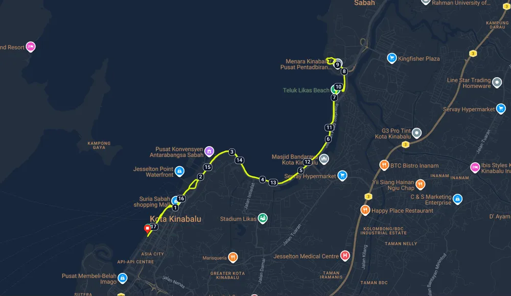
Route Overview & Telemetry
- Start/End Point: Le Méridien Kota Kinabalu (Pusat Bandar)
- Turnaround Point: Menara Tun Mustapha (Sabah Foundation Building)
- Total Distance: ~18 km (11.1 miles) out-and-back [Note: Can be shortened by choosing intermediate turnaround points]
- Terrain: 100% Paved, flat asphalt and colored-tar pedestrian/bike paths.
- Traffic Level: Extremely low; isolated from main road structures.
The Turn-by-Turn Route Breakdown
[Le Méridien KK] ➔ (Right Turn) ➔ [Merlin Marlin Statue] ➔ [Jesselton Point Ferry Terminal]
                                                                     │
[Menara Tun Mustapha] 🖚 [PPNS Vehicle Bridge] 🖙 [Shared Coastal Bike/Run Track Ends]
Phase 1: The Waterfront Warm-Up (KM 0 to KM 2)
Exit the front lobby of Le Méridien Kota Kinabalu and immediately turn right onto the main coastal boardwalk path heading north. Within a few hundred meters, you will pass the iconic local Marlin (frequently called the Merlin) statue. Use this flat, sea-breeze-cooled stretch to lock in your target aerobic heart rate. Continue tracking north past the historic Jesselton Point Ferry Terminal.
Phase 2: The Likas Bay Cruise (KM 2 to KM 6.5)
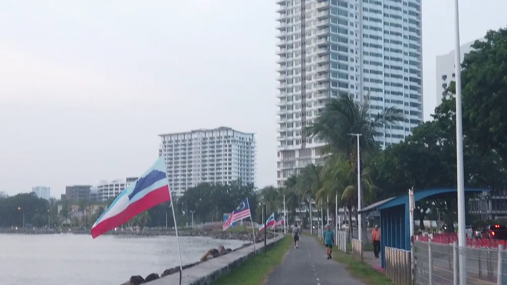
As you pass Jesselton, you will transition onto a beautifully engineered, dedicated shared bicycle and running track. This segment hugs the curve of Likas Bay. The views across the South China Sea are wide open, and because the track sits entirely away from the highway, the ambient acoustic environment is exceptionally quiet. You can easily lock into a rhythmic tempo or zone 2 cruise without looking out for crossing traffic.
Phase 3: The Technical Overpass & The Floating Tower (KM 6.5 to KM 9)
Once the main shared coastal track concludes near the Sabah State Legislative Assembly area, navigate a brief series of turns to ascend the modern PPNS vehicle overpass bridge. Crossing over this bridge offers sweeping elevated vistas of the surrounding coastal mangrove ecosystems.
Directly on the other side sits your destination: Menara Tun Mustapha (The Sabah Foundation Building). As a trainer, I love routes that finish a major leg at a visual landmark. This 32-story, 122-meter cylindrical tower is a masterpiece of architectural engineering. It is one of only four buildings globally built as a “hanging structure”. It features a central core with high-tensile steel brackets supporting each floor invertedly—meaning the building is structurally suspended from above rather than stacked from the ground up.
Phase 4: The Recovery Return (KM 9 to KM 18)
After taking a lap around the tower plaza to marvel at the engineering, pivot 180 degrees. Re-cross the bridge and open up your stride on the continuous, flat coastal paths all the way back to the hotel.

Mr. Gutang’s Training Tips for Kota Kinabalu
- Beat the Tropical Humidity: Being near the equator, Kota Kinabalu hits high humidity early. Start your watch no later than 6:00 AM to capture the cooler morning air, or timeline your departure for 5:30 PM to sync your return leg with Sabah’s world-famous coastal sunsets.
- Hydration Logistics: While the route is highly isolated from heavy traffic noise, it is also unshaded. Carry a handheld flask or hydration belt. There are only a few public water stops once you clear the ferry terminal area.
- Footwear Recommendation: Because the entire path consists of modern, hard asphalt and concrete brick pavers, opt for your highly cushioned daily trainers or marathon racing shoes to safeguard your joints over the high-volume mileage. No need for trail shoes or “gravel”
The Likas Track Extension: Precision Kilometer Tuning
For marathoners and triathletes executing precise interval workouts, tempo blocks, or looking to round up their data screens to an even kilometer, a standard 400-meter track is invaluable.
Conveniently, the Likas Sports Complex is located immediately adjacent to the Likas Bay coastal path. It serves as the perfect mid-run detour to calibrate your target metrics without adding messy, unpredictable street mileage.
[Coastal Track: Likas Bay] ➔ (Left Detour) ➔ [Likas Sports Complex 400m Track] ➔ (Right Return) ➔ [Resume Coastal Track]How to Access the Track Mid-Run
As you run north along the Likas Bay path (Phase 2), look to your left around the 4.5 km mark from Le Méridien. You will see the expansive grounds of the Likas Sports Complex. Leave the coastal path, cross the pedestrian-friendly access roads, and enter the public athletic complex area.